
Once an open cast coal mine, now in the process of becoming a country park and RSPB reserve. It seems the land ownership issues are not finally settled. Although the lawyers are still dancing their slow circling dance, the footpaths and bridleways are now open for visitors to enjoy.
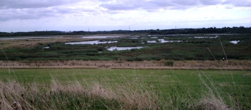
The whole site is interesting. Back in 1988, the River Aire broke into the opencast workings; the hole was so deep, that the river flowed backwards for several days. Recovering the mine involved reconstructing and combining the river and canal in one channel, and creating a wetland site with a series of large pools, islands, reed beds, grasslands, and woods.
Coal production finally stopped only in 2002, so exploring the perimeter bridleway and network of footpaths gives one a good feel for how nature takes over and heals industrial scars.
There is a wealth of bird life, especially waterfowl. I spent a happy hour watching a flock of hundreds of Greylag geese (and a few Canadas).
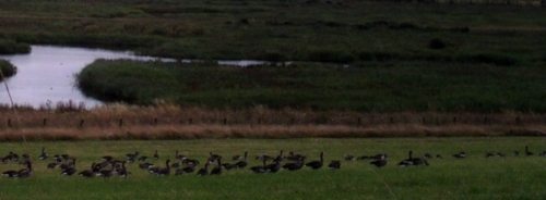
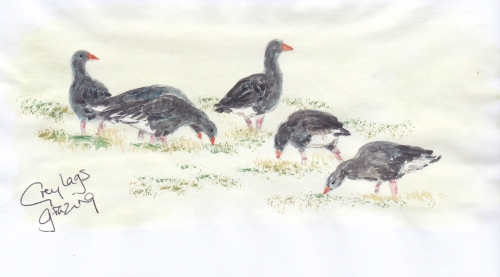
As I hunkered down into some long grass, their long-necked wariness relaxed. They resumed their grass grazing, and gradually came within twenty or thirty feet of me. Just the occasional bird standing sentinel.

So calm and peaceful – until some moronic pillock arrived with his pit-bull, which he let loose “for some exercise”.
I saw herons and cormorants, and various ducks. This is going to be a regular ride through late September and October, just to watch out for migrant geese coming in from northern parts to overwinter. It is just that bit closer than Fairburn Ings, and will involve a lot less riding on roads in poor light.

Hard to miss – the huge dragline excavator, nicknamed “Oddball” because of the strange noise its electric motors made. It used to be capable of “walking” at a top speed of approximately (!) 0.2 mph. Built in the US by Bucyrus Eyrie, at 1,200 tonnes, it was once the largest such machine in the world. And now? It is perhaps the world’s largest nesting box for owls and kestrels.
It has been a landmark for as long as I remember, and is now maintained as a monument to the “sunshine miners”. Just occasionally, it is open to visitors; I’m looking forward to getting into its oily bowels on the 13th/14th September. [Repeating the run]
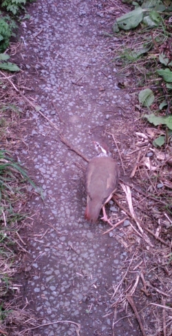 On the ride home, I met this little fella. I came round the corner, and he froze on the path, mid-step, just a metre ahead.
I froze.
Oh so slowly, slowly, I extracted my camera from my pocket. Still he kept that beady eye on me.
Our stand-off lasted several minutes. When I finally moved forwards, he scuttled off in front of me for twenty yards, before clattering into flight.
The RSPB says of the quail “Very difficult to see – easier to hear, usually calling from grass or cereal fields.” I count myself honoured.
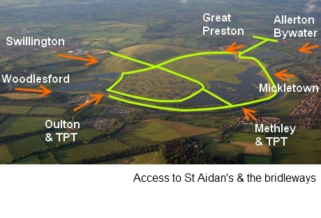
Getting there
 Using The Lines Way
- From Garforth/East Garforth Station, ride as far as Brigshaw High School. Take the steps up to the road, cross back over the bridge, head up the hill to the main road, and turn left. At the bright yellow shop, take a right, which will take you to the main entrance and visitor centre.
- From Castleford Station, as you pass east of Allerton Bywater, you will come to Bowers Junction. Swing right, cross the main road, and follow the bridleway into the park.
- or, from the Boat Inn in Allerton Bywater, follow the footpath along the river bank.
- From Leeds – follow the Aire and Calder Navigation path past Woodlesford (or take the train to Woodlesford Station); cross the A642. Follow the Trans Pennine Trail along the canal bank as far as the Bayford oil depot at Lemonroyd; the trail goes round the back, and you can access the perimeter bridleway here.
- From the mini-roundabout at the end of Mickletown Main Street, head for the river/canal. Turning right takes you to a bridge onto the perimeter bridleway at the east end of the park; turning left, to another bridge and access to the perimeter and the central “cross” bridleways.
- From Temple Newsam, head for the bridge at the south (lower) end of the lakes, and follow the paths signposted for Bullerthorpe Lane, along The Avenue. At the main road, look to your left and you will see a bridleway about thirty yards away on the other side; follow that, over the M1 bridge, past Upper Hall Farm and Hollow Drift. Turn right for Swillington, and take a left on to Church Avenue or Church Lane; head for Swillington Parish Church. Cross straight over the A642. Take Astley Lane ahead of you – at the end of the village, there is a spur to the right which leads on to a bridleway. This will take you in to the north end of St Aidans, giving a fine perspective over the wetlands and pools.
Links

Hi Gavin, your posts are very interesting and the way you describe your travels is a joy to read. You have a great talent both in your written word and drawings. I look forward to reading the next instalment.
Paul
LikeLike
Goodness – thank you very much, Paul; very much appreciated!
LikeLike