
Revisiting a “bumpy” little corner south east of Leeds. The hills are certainly not big, but there are a lot of them. Plenty to see, interesting perspectives and views to enjoy, but fairly strenuous on a bike if you stick to the roads.
 There is a better way. The Leeds, Castleford and Pontefract Junction Railway (LC&PJR)* built a line primarily to serve the coal mines in the area. A quick google, and there’s any number of atmospheric photographs of the line, both in its heyday and as it declined until the 1998 closure of the last section between Ledston and Castleford. Naturally, it follows the easiest route round the hills, through cuttings, and along embankments. Ideal cycling – and it is now The Lines Way, a four mile leisure route for walking, cycling, and horse-riding.
For several years, 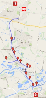 this part of NCN Route 697 was my “fine riding” commute to Castleford; worth getting up fifteen minutes early for.
Downhill in the morning, gentle uphill home; work was just the boring bit between bike rides. At that time, of course, the Boat Inn in Allerton Bywater was a brew pub and producing some excellent ales. I’d leave work and cycle about a mile – time for a quiet pint on a bench overlooking the River Aire, watching the waterfowl, and completing the Guardian quick crossword. Happy days.
For the most part the surface is not made up – but it is mostly firm and hard. Possibly a bit rough for many road-bikes, but that depends on one’s tolerance; think reasonable canal towpath surface
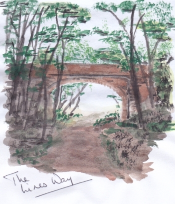 Out of Garforth, I slipped under the main Leeds-Selby Road into a cutting, lined either side with fine oaks and sycamores. Deep, dark, and damp; the smell of wet woodland floor – that “warm” smell of slowly rotting vegetation and timber.
On into more open countryside, following the course of the Kippax Beck, with substantial wild hedgerow on either side, thick with ripe brambles and hawthorn berries at this time of year. Fine views across the valley, over rich and fertile farmland. (An especially fine ride in spring time, when the undergrowth is alive with nesting songbirds.)
The railway crosses the beck, barely visible through the undergrowth. And then I “arrive” at Kippax Station. Not that there’s anything left of it now; it’s just an empty space. Oddly though, it is a space that I feel compelled to fill, entirely in my imagination, from memories of old photographs.
Back into a wooded cutting, like a damp cathedral, below Brigshaw High School. In winter and spring, heavy rain can make this section impassable.
- Bad weather alternative
- Head for the footpath immediately to the left of the garage/workshops at the far end of the old station site, and take the farm track between the school and the old railway. This takes you uphill and back to The Lines Way at Allerton Bywater.
- Coming from Castleford, as the Lines Way passes Allerton Bywater village, it drops to and crosses a tarmacked lane. I turn right and keep going on to the farm track. Incidentally, this takes you by Owl Wood – the colliery here, once a major local employer, closed in 1904. The coal cutting machines first used in Yorkshire appeared at Owl Wood Colliery and Bowers Main Collieries.
[To explore St Aidan’s Country Park]
After the cutting, it feels a little strange riding along the embankment – almost as if I’m cycling through the tree tops.
It must be ten years ago when I commuted this section – I have fond memories of being recognised as a “regular” by “real” regulars. Mostly they were retired miners taking the dog for a walk, many old beyond their years and obviously in poor health.
As I write however, it strikes me that I saw no old miners today. Not one. I wonder if they may have paid the price of working in the coal industry? A hard way of life gone. And with it perhaps, (what I think of as) the Allerton Bywater accent; like nothing I’ve heard elsewhere in Yorkshire. I used to occasionally stop for a chat with guys working their allotment plots – just to enjoy the accent. All I heard today was standard “city Yorkshire”.
The trail comes to an end, and drops to Park Lane.
The signage suggests going straight ahead, where the railway used to run into the mine workings. That takes you into Allerton Millenium Community – if a 21st century housing estate tickles your fancy, go right ahead.
With apologies to any resident who finds this through Google – but the one time I rode through, I wanted to sing Malvina Reynolds’ “Little Boxes” at the top of my voice. A corporate architect’s characterless and cramped pastiche of old Amsterdam, God help us.
So I turn right, take a left the old school towards the church, straight over the cross roads, round by the river bank to the Boat Inn, and follow the footpath. At the end of the paved section, take the track across the field to the main road and on to Castleford.
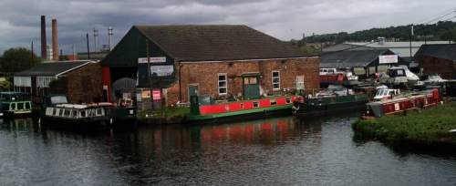
Or – stick by the river bank, and you come to Castleford Junction, where the Rivers Aire and Calder, the Aire and Calder Navigation, and the canal extension to Wakefield all meet. Round the corner, you come to a still-thriving canal hub, with boat builders, chandlery, and marine engineering. Not the only interesting facet of Castleford you will miss from the windows of a car – the town is also a traditional overwintering spot for many fairground traveller families.
* Sorry, but Ivor the Engine comes to mind!
To get to The Lines Way
- Turn left out of Garforth Station into Station Way, left again into Church Place, left again when you get to the Parish Church of St Mary, and right at The Podger pub; straight along the road to the road narrows feature at the bottom of the hill, and turn right through the barriers.
- From East Garforth Station, turn right towards town, and left at the main road; and again down the hill to the road narrowing feature.
- From Castleford Station, head for the main road north – the A656 (the old Roman Road to the north). The first bridge takes you over the River Aire, and the second over the Aire and Calder Navigation. Very soon after, there’s a field entrance on your left – go through the gate, and follow the footpath over the fields, past the Boat Inn, and along Allerton Bywater “waterfront”. At the main road, go straight ahead past the church and the old school, and turn right. The entrance to The Lines Way is a hundred yards or so past the allotments, on your left.
- Or cycle to Garforth from Cross Gates or Leeds!
